Introduction

The purpose of the Green Infrastructure Toolkit is to provide local leaders with training resources, planning tools and initiatives, environmental insights, funding opportunities, and environmental justice tools that will support the goals of the Chesapeake Bay Watershed Implementation Plan and create a more equitable, biodiverse, and sustainable community.  

Like a garden, the local environment needs the right nutrients, clean water, and habitats to flourish. Pollution and development have harmed the health of the Chesapeake Bay Watershed, threatening the long-term viability of both the ecosystem and economy. Virginia’s Chesapeake Bay Watershed Implementation Plan, or WIP, was developed to restore the natural balance of the watershed and ensure its sustainability.

Virginia’s WIP is a roadmap for restoring the health of the Bay by 2025.  It was established in response to the federally led and legally binding Chesapeake Bay Agreement. It outlines the steps needed to reduce water pollution, improve water quality, and protect the Bay’s ecosystem and economy. The detailed strategy calls for action from local governments within the Bay to meet its established goals.

Local government officials play a critical role in implementing the WIP by:

    • Educating constituents about the importance of achieving nutrient balance in the Bay watershed.
    • Encouraging the adoption of best management practices (BMPs) by businesses and residents.
    • Supporting public and private investment in green infrastructure projects.
    • Adopting and enforcing environmental regulations.

Investing in the health of local waterways and the entire watershed provides a number of benefits to communities away from the coastline by:

    • Improving water quality: for drinking, fishing, swimming and other recreational activities.
    • Reducing Flooding: By reducing runoff, the WIP reduces flooding that damages infrastructure and disrupts economic activity.
    • Increasing economic activity: The WIP creates jobs in the construction, engineering, and environmental services sectors. It also supports local businesses that rely on clean water and healthy ecosystems, such as tourism, fishing, and agricultural industries.
    • Improving public health: Exposure to polluted water can lead to a variety of health problems, including respiratory infections, gastrointestinal illnesses, and cancer. By improving water quality, the WIP helps reduce these health risks.
    • Increasing recreational opportunities: Improved water quality can lead to increased opportunities for swimming, fishing, boating, and other recreational activities, which can boost tourism and the local economy.
    • Enhancing habitat for fish and wildlife: Cleaner water and healthier ecosystems provide better habitat for fish and wildlife, which can support commercial and recreational fishing and hunting industries.

The purpose of the toolkit is to equip local leaders with resources to support the realization of their role in supporting the Chesapeake Bay.

Educational and Training Resources

Government officials and staff who work in the Chesapeake Bay watershed can review the following training resources to better understand the environmental and economic importance of the bay, sources of pollution, and the role of local government in reaching Virginia’s water quality goals.

Protect Local Waterways A guide on how local government leaders can help protect the health and vitality of local waterways. Local leaders make decisions that set the course for their community. Their actions set the direction for the environmental health and vitality of their jurisdictions which impact local waterways and the Chesapeake Bay. The learning library contains modules on various topics from Preserving Local Character and Landscapes to Building the Workforce of Today and Tomorrow. These modules consist of fact sheets, video presentations, case studies from other communities, and resources to learn more about each topic.

Municipal Online Stormwater Training Center The MOST Center was established in 2015 to bridge the gap in needed technical and financial stormwater management resources in the Chesapeake Bay Watershed.  This virtual center provides users with tools to better communicate about, build, and enhance local stormwater programs.

Through interactive lessons, videos, graphics, and knowledge checks, MOST delivers educational content in an engaging, user-friendly format.  In addition, the site features case studies that demonstrate local success, interviews with practitioners around the Chesapeake Bay region, and helpful resources such as manuals, reports, and toolkits.

Land Instruments and Green Infrastructure

Below are resources that describe planning and regulatory tools that can be implemented by local governments to support water quality, promote resilience, and protect economic and environmental resources. In most cases, model ordinances are provided.

Model Ordinances to Prevent and Control Nonpoint Source Pollution Legal authorities shape development and can protect natural resources. This website supports local governments by providing information to develop effective resource protection ordinances. The ordinance types address topics such as aquatic buffers, erosion and sediment control, open space development, stormwater control operation and maintenance, illicit discharges and post construction controls.

Wetland Watch’s Adaptation Guide provides a Virginia-specific guide of existing programs and authorities that local governments could use today to take action on water quality, flooding, and sea level rise. The guide includes insights into regulatory tools such as:

  • Floodplain Management: Local governments can establish more restrictive floodplain regulations and incentivize smart floodplain management, open space preservation, and retention or restoration of natural floodplain functions to help meet water quality goals.
  • Chesapeake Bay Preservation Act: The Act grants localities the authority to prohibit development in shoreline areas; establish, restore and expand natural buffers; minimize land disturbance/impervious cover; protect indigenous vegetation; and provide for erosion and sediment control. Every coastal locality in Virginia is required to have a local CBPA ordinance, but non-coastal localities can voluntarily adopt provisions of the act to shape new development and redevelopment.

The Virginia Tree Ordinance Database (VTOD) is a repository of municipal ordinances in Virginia that regulate the use, management, and conservation of trees in urbanized areas. The purpose of this website is to provide citizens, professionals, and elected officials with information they can use to craft tree ordinances for their communities.

The database is not a tutorial or instruction manual for writing ordinances. Rather, it provides examples of common tree ordinance terminology and content, which has been excerpted from ordinances of 37 municipalities across Virginia.

The Georgetown Climate Center Green Infrastructure Toolkit is intended to aid local governments nationwide in comparing best practices across cities, drawing lessons from different approaches enabling them to craft similar policies for their own jurisdictions. The purpose of the toolkit is to analyze common trends in the approaches various cities take to planning, implementing, and funding green infrastructure BMPs.

TJPDC Green Infrastructure Study (2009) The TJPDC Green Infrastructure Study is intended to identify an interconnected green infrastructure network for the Thomas Jefferson Planning District region and provide information on implementation measures for consideration in local planning processes. The study details green infrastructure cornerstones by county, barriers to implementation, and a variety of development tools to support green infrastructure.

The Chesapeake Bay Program Quick Reference Guide for Best Management Practices provides summarized profiles for approves green infrastructure approaches and best management practices to support the goals of the Chesapeake Bay Watershed Implementation Plan.

Environmental Justice

Many local governments are incorporating equity and environmental justice in their climate adaptation and watershed planning by recognizing the disproportionate impacts of climate change on underserved communities and striving to ensure that all residents benefit from adaptation efforts. Below are a few tools to identify overburdened communities and better understand various aspects of social and environmental vulnerability.

EPA’s EJSCREEN tool identifies communities who may face a higher risk of environmental harm.

The Chesapeake Bay Program developed the Chesapeake Environmental Justice and Equity Dashboard to better understand how work related to land conservation and public access can result in a more inclusive and equitable region.

The Climate and Economic Justice Screening Tool highlights disadvantaged census tracts that are overburdened and underserved.

The Chesapeake Conservation Partnership has partnered with Skeo Solutions to create the Green Space Equity Mapper to help prioritize conservation in low-income communities and communities of color with limited access to open space throughout the watershed. This web-based map tool includes a set of interactive map layers to help conservation organizations and community groups identify areas most in need of green spaces and assess how these gap areas relate to demographics, community risks and land cover. 

The DEQ Office of Environmental Justice works collaboratively to advance environmental justice (EJ) in Virginia. The office assists EJ community members in navigating environmental programs in Virginia.

Costs and Benefits of Green Infrastructure

Explore the co- benefits and cost considerations of green infrastructure and learn about  the ways other communities have estimated the multiple environmental, economic, and community benefits of their green infrastructure investments.

Funding Opportunities

Below is a list of funding programs available to local governments in our region that support the implementation of green infrastructure and water quality advancements.

Water Quality

Water quality in the Thomas Jefferson Planning District is monitored by the Department of Environmental Quality (DEQ), Virginia Department of Health (VDH), local governments, and nonprofits. Water quality in Virginia is determined by a Total Daily Maximum Load (TMDL) which identifies the maximum amount of a pollutant that a water body can receive and still meet water quality standards.

TMDLs are developed by DEQ for water bodies that are tested and found to be impaired, meaning they do not meet water quality standards for one or more designated uses.

The primary designated uses are: 1) wildlife, 2) aquatic life, 3) fish consumption, 4) shellfish harvest, 5) recreation (primary and secondary contact) and 6) public water supply use. Read DEQ’s methodology for assessing the water quality of Virginia’s streams, lakes and estuaries as part of the Final 2022 Water Quality Assessment Integrated Report of water quality conditions in Virginia.

Typically, an implementation plan is developed by DEQ or a community watershed group following approval of a TMDL. Implementation plans detail actions to improve local water quality based on the observed pollutants impacting the stream or watershed. EPA approved implementation plan’s can provide the area with additional funding to support restoration efforts.

Virginia’s Water Quality Improvement Process:

  1. Identify impaired waters. This is done by collecting water quality data and comparing it to water quality standards.
  2. Develop TMDLs. Once impaired waters are identified, DEQ develops TMDLs by calculating the amount of each pollutant the water body can reach to meet water quality standards
  3. Implement TMDLs. DEQ and local stakeholders then implement the TMDL by integrating best management practices into the surrounding watershed or by enforcing regulations that reduce pollution.
    1. An Implementation Plan is a document that outlines the steps needed to implement a TMDL. They identify the needed nonpoint source best management practices, a cost benefit analysis, measurable goals, and a timeline to achieve water quality objectives. Implementation Plans can make Clean Water Act Section 319(h) funding available to the area for implementation of BMPS, education and outreach, and water quality monitoring.
  4. Continue to evaluate water quality changes through continued monitoring.

DEQ’s Environmental Data Mapper displays water monitoring sites and current or ongoing Implementation Plans and TMDLs across the state.

The State of the James is a report card summarizing ongoing efforts to bring the James River back to full health. This comprehensive assessment of the health of the river is published every two years.

Rivanna River Watershed Stream Health Reports are developed each year by the Rivanna Conservation Alliance based on water monitoring data collected by the local River Stewards.

Chesapeake Progress tracks progress towards the goals and outcomes of the Chesapeake Bay Watershed Agreement. As of 2023, there has been a recent decrease in progress and the overall outlook is off course for 2025.

A Comprehensive Evaluation of System Response (CESR), summarizes the Chesapeake Bay Program’s Scientific and Technical Advisory Committee (STAC) evaluation of why progress toward meeting the TMDL and water quality standards has been slower than expected and offers options for how progress can be accelerated. CESR is a summation of a three year investigation into the 40 year effort to reduce nutrient loads to Chesapeake Bay.

Additional Indicators:

Chesapeake Tree Canopy Network Understand Your Canopy

New county fact sheets are now available for all jurisdictions within the Chesapeake Bay Watershed, sharing tree cover status, tree cover benefits, and change information over the 2013/14 to 2017/18 time periods.

Watershed Related Planning Initiatives

Glossary

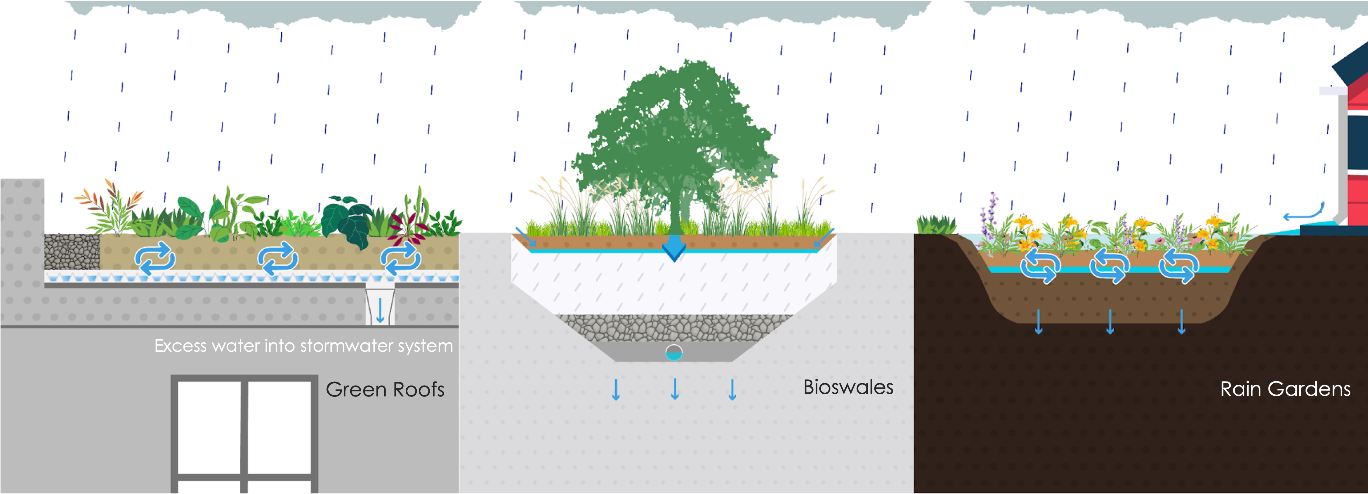
Best Management Practice (BMP) – refers to techniques found to be most effective and practical for a particular situation. In the case of stormwater, BMPs intend to reduce the volume of runoff and/or eliminate pollution and contaminants collected by runoff before reaching local waterways.

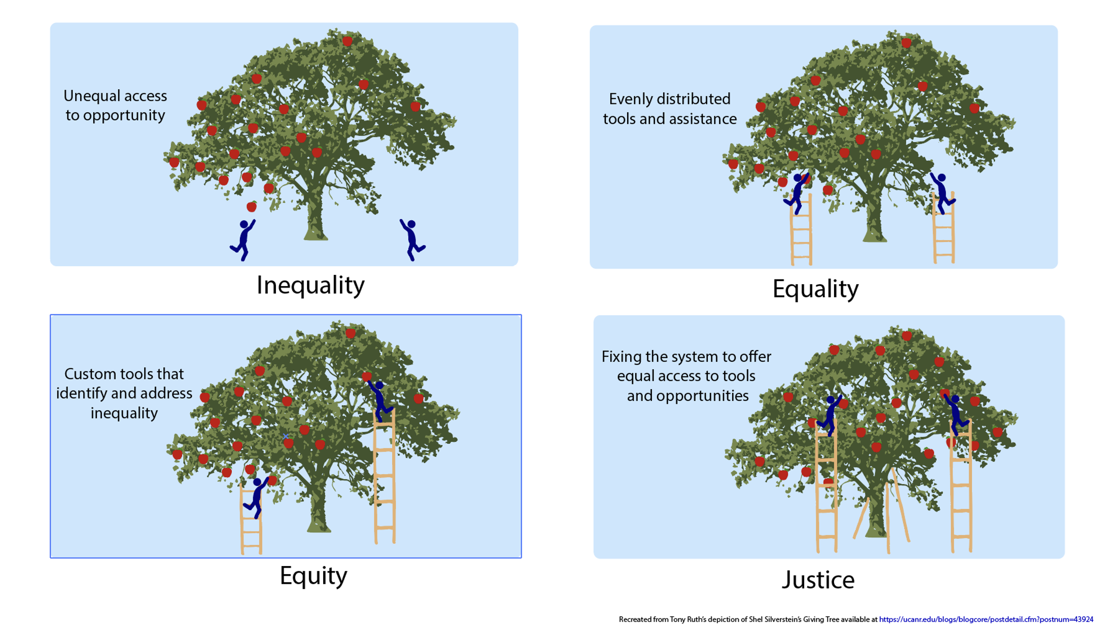
Environmental Justice – is the fair treatment and meaningful involvement of all people regardless of race, color, national origin, or income, with respect to the development, implementation, and enforcement of environmental laws, regulations, and policies.

Green Infrastructure – natural or engineered systems that mimic the way nature works.

Impervious or Impermeable Surface – a surface that prevents water infiltration into the soil. They are typically made of man-made materials, such as asphalt, concrete, and metal.

Permeable (or pervious) – allowing water to pass through.

Stormwater Runoff– rain or snowmelt that runs off from impervious surfaces, such as rooftops, roads, and parking lots, into streams and ultimately the Bay itself, carrying pollutants, including nutrients, sediment, bacteria, and chemicals.

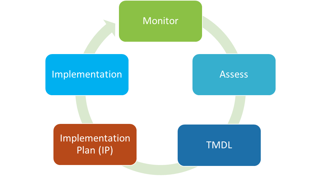
Total Maximum Daily Load (TMDL) – is a scientific determination of the maximum amount of a pollutant that a body of water can receive and still meet water quality standards.

Urban Heat Island Effect – a phenomenon that developed areas are warmer than their rural surroundings due to reduced natural landscape and heat generating human activities

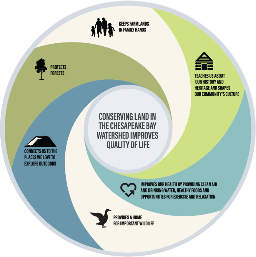
Watershed Implementation Plan – a detailed, practical strategy for how Chesapeake Bay states and the District of Columbia, in partnership with federal and local governments, will attain the Chesapeake Bay TMDL.