WATERSHED IMPLEMENTATION PLAN (WIP)
What is a Watershed Implementation Plan?
Watershed Implementation Plans or WIPs, are the roadmap for how Chesapeake Bay states and the District of Columbia, in partnership with federal and local governments, will attain the Chesapeake Bay TMDL. Recently, Bay states worked with local stakeholders to develop the third phase of their WIPs. The Phase III WIPs include an update of state and federal strategies and the identification of new pollutant reduction strategies with a special focus on sustained local engagement and strategies.
Helpful Terms
Total Maximum Daily Load (TMDL): A calculation determining the amount of a pollutant that can be present in a waterway, while meeting water quality standards.
Local Area Planning Goals (LAPGs): Pollutant reduction goals established for local communities, that usually include more localized TMDLs for pollutants like Nitrogen, Phosphorus, sediment, and others.
Best Management Practices (BMPs): reduce nitrogen, phosphorus and sediment loads to
the Chesapeake Bay and improve local water quality. More information about research based BMPs is available in the Chesapeake Bay Program’s BMP Reference Guide.
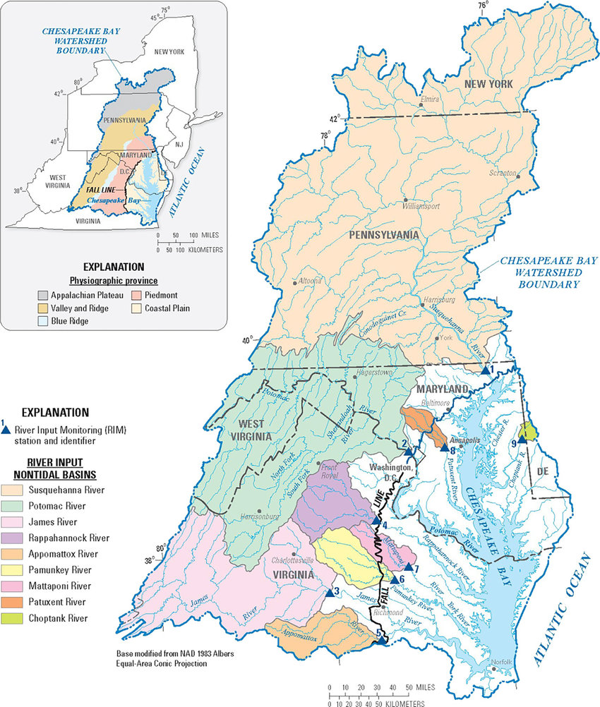
Watershed Map
Stewardship Assessment and Mapping Project
The Stewardship Mapping and Assessment Project (STEW-MAP) of the Thomas Jefferson Planning District is a survey and public database designed to map where stewardship organizations work and how they are connected, with the goal of strengthening community capacity for environmental stewardship within the region. STEW-MAP was developed by the USDA Forest Service in New York in 2007. Since then, the framework has utilized from Seattle to Beijing. Each project is conducted separately by a local research team in partnership with local agencies and organizations.
TJPDC'S CHESAPEAKE BAY TMDL EFFORTS
The Thomas Jefferson Planning District Commission was contracted by the Virginia Department of Environmental Quality to coordinate the region’s urban sector stakeholder input process for the development of Phase I and II Watershed Implementation Plans. Some topics of inclusion for the input process were stormwater management, septic systems, and urban forestry. For the Phase III WIP, the district compiled lists of Best Management Practices to meet the region’s TMDL goals. DEQ aggregated feedback from each planning district into a state level plan.
The TJPDC continues to collaborate with the Virginia DEQ and other partners to reduce loads of nitrogen, phosphorus, and sediment for the Chesapeake Bay TMDL by providing educational resources to the region and technical assistance to local governments and other stakeholders in the region. Below are a few of the ways the TJPDC can support local and statewide water quality improvement goals.
Assistance with implementation of stormwater management practices
.
Supporting education on best management practices
Grant writing assistance for watershed protection
Assistance developing water quality plans, programs, and policies
“Environmental Justice is the fair treatment and meaningful involvement of all people regardless of race, color, national origin, or income, with respect to the development, implementation, and enforcement of laws, regulations, and policies.
Fair treatment (non-discriminatory actions) is the fair and equitable treatment of all whereby no group of people bear a disproportionate share of negative environmental consequences resulting from environmental decisions.
2. Meaningful involvement is the guarantee that:
Impacted and vulnerable community residents have a realistic opportunity to participate in the full cycle of the decision-making process about a proposed activity that will affect their environment and/or health;
Decision-makers will seek out and consider participation, allowing it to shape and influence the decision.”
–Virginia Environmental Justice Collaborative
Mapping and Screening Tools:
ADAPT Virginia is an information gateway on climate change adaptation for individuals, local programs, and agencies and integrates best available science, legal guidance, and planning strategies. The mapping tool can help assess risk and vulnerability to climate impacts, build community resiliency against extreme events, and provide guidance to prepare and respond to a changing environment.
CDC Social Vulnerability Index employs U.S. Census Bureau variables to help users identify communities that may need support in preparing for hazards or recovering from disasters. The tool is particularly useful for emergency response planners and public health officials, as it can identify and map the communities that are most likely to need support before, during, and after a hazardous event.
Climate and Economic Justice Screening Tool (CEJST) is a geospatial mapping tool to identify disadvantaged communities that face burdens. The tool has an interactive map and uses datasets that are indicators of burdens.
Federal agencies will use the tool for the Justice40 Initiative. It will help them identify disadvantaged communities that should receive 40% of the overall benefits of programs included in the Justice40 Initiative. The Justice40 Initiative seeks to deliver 40% of the overall benefits in climate, clean energy, and other related areas to disadvantaged communities.
EJScreen is EPA’s environmental justice mapping and screening tool that provides EPA with a nationally consistent dataset and approach for combining environmental and demographic socioeconomic indicators. This screening tool and data may be of interest to community residents or other stakeholders as they search for environmental or demographic information. EJscreen can support educational programs, grant writing, community awareness efforts, and many other purposes.
FEMA National Risk Index is a dataset and online tool to help illustrate the United States communities most at risk for 18 natural hazards. Social vulnerability is the susceptibility of social groups to the adverse impacts of natural hazards, including disproportionate death, injury, loss, or disruption of livelihood.
The Regional Environmental Coordination (REC) meeting convenes land use managers, planners, and environmental managers to collaborate and share knowledge on environmental initiatives. These meetings facilitate discussion and information exchange on local, state, and federal environmental topics, regulations, and programs. Subject matter experts from state, nonprofit, and other organizations will present relevant insights. The REC also serves as a platform for state officials and stakeholders to share information with localities and gather feedback on land use and environmental programs.
Regional Environmental Coordination meetings are held quarterly. Contact Isabella O’Brien at iobrien@tjpdc.org or 434-422-4824 for more information.
The TJPDC is a partner to the #LoveYourWatershed campaign.
Mission: The Love Your Watershed campaign is designed to motivate residents of the greater Charlottesville area to reduce their impact on waterways and ultimately improve local water quality and ecosystems. This campaign works by encouraging exploration of local waters and watersheds, showing how and why our waterways struggle, and facilitating action on a personal and community level.
Due to known impairments in our local waterways, the content of this campaign focuses on stormwater runoff and sources of bacteria and sediment pollution.
Learn More
- Rivanna Stormwater Education Partnership Website
- Rivanna Stormwater Education Partnership Virtual Campaign
- #LoveYourWatershed Social Media Content
- Illicit Discharge & Detection Reporting Form: Report illegal dumping or pollution in local waterways
WORDS FROM YOUR WATERSHED
Words From Your Watershed is an e-newsletter developed by the Thomas Jefferson Planning District Commission to connect water quality funding opportunities, news, educational resources, and events with the regional community and locality partners to support implementation of solutions to local and statewide water quality issues. Share this newsletter to increase awareness of the many opportunities available to engage with your watershed or improve its health.