Green Infrastructure Toolkit
Table of Contents Introduction Educational and Training Resources Land Instruments and Green Infrastructure Environmental Justice Costs and Benefits of Green Infrastructure Funding Opportunities Water Quality Watershed Related Planning Initiatives Glossary Introduction The purpose of the Green Infrastructure Toolkit is to provide local leaders with training resources, planning tools and initiatives, environmental insights, funding opportunities, and environmental justice tools that will support the goals of the Chesapeake Bay Watershed Implementation Plan and create a more equitable, biodiverse, and sustainable community. Like a garden, the local environment needs the right nutrients, clean water,…
Stewardship Assessment and Mapping Project
What is STEW-MAP? The Stewardship Mapping and Assessment Project (STEW-MAP) of the Thomas Jefferson Planning District is a survey and public database designed to map where stewardship groups work and how they are connected, with the goal of strengthening community capacity for environmental stewardship within the region. STEW-MAP was developed by the USDA Forest Service in New York in 2007. Since then, the framework has utilized from Seattle to Beijing. Each project is conducted separately by a local research team in partnership with local agencies and organizations. STEW-MAP addresses the…
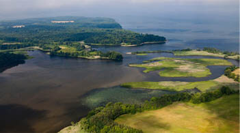
Watershed Implementation Plan (WIP)
What is a Watershed Implementation Plan? Watershed Implementation Plans or WIPs, are the roadmap for how Chesapeake Bay states and the District of Columbia, in partnership with federal and local governments, will attain the Chesapeake Bay TMDL. Recently, Bay states worked with local stakeholders to develop the third phase of their WIPs. The Phase III WIPs include an update of state and federal strategies and the identification of new pollutant reduction strategies with a special focus on sustained local engagement and strategies. Helpful Terms Total Maximum Daily Load (TMDL): A calculation…